Garmin GPSMAP 1042xsv Review
Brand: Garmin | Model: 010-01740-21 | Our Score: 5/5
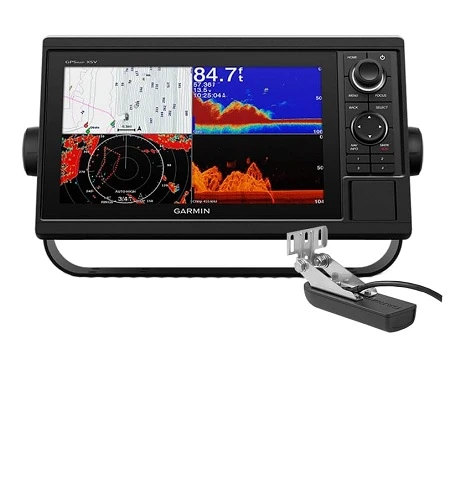
The Garmin GPSMAP 1042xsv, an all-in-one, fully networkable chartplotter and fishfinder, is a top choice for boaters. Its 10.1-inch screen offers easy viewing, and the user-friendly interface includes a keypad and a multifunction control knob. The GPSMAP 1042xsv has the GT52-TM transducer, known for clear sonar images with Garmin CHIRP, ClearVü, and SideVü.
The GPSMAP 1042xsv is made for any weather and has manual knobs for easy control. It also keeps you safe with Sirius XM weather updates. Its capabilities extend to detailed side-down scans and QuickDraw, making it an essential tool for boaters seeking precision.
This fully networkable GPS chartplotter and sonar combo is versatile, offering the GT52 transducer for deep-water fishing and supporting all Garmin marine radars. It also boasts dual network ports and GSD black box support.
In our review, we will look at the specifications and features and answer common questions about them.
Garmin GPSMAP 1042xsv Specifications
| Specifications | Garmin GPSMAP 1042XSV Specifications |
|---|---|
| Dimension | 12.5″ x 7.3″ x 2.7″ (31.8 x 18.5 x 6.9 cm) |
| Weight | 4.1 lbs (1.85 kg) |
| Waterproof | IPX7 |
| Display Type | WSVGA, NP |
| Display Size | 8.8″ x 4.9″; 10.1″ diagonal (22.4 x 12.5 cm; 25.7 cm diagonal) |
| Display Resolution | 1024 x 600 pixels |
| Mounting Options | Bail or flush |
| Input | Keyed |
| Accepts Data Cards | 2 SD™ cards |
| Waypoints | 5000 |
| Track Points | 50,000 |
| Tracks | 50 saved tracks |
| Navigation Routes | 100 |
| GPS | Yes |
| Glonass | Yes |
| Has Built-In Receiver | Yes |
| Receiver | 10 Hz |
| Nmea 2000 Compatible | Yes |
| Nmea 0183 Compatible | Yes |
| Supports Waas | Yes |
| Bluechart (Coastal) | Yes |
| Lakevu (Inland) | Yes |
| Tide Tables | Yes |
| Bluechart G3 | Yes |
| Bluechart G3 Vision | Yes |
| Lakevü G3 | Yes |
| Lakevü G3 Ultra | Yes |
| Garmin Navionics+™ | Yes |
| Garmin Navionics Vision+™ | Yes |
| Topo 100k | Yes |
| Standard Mapping | Yes |
| Garmin Quickdraw Contours | Yes |
| Raster Chart Support | Yes |
| Smart Mode Compatible | Yes |
| AIS | Yes |
| DSC | Yes |
| Supports Fusion-Link™ Compatible Radios | Yes |
| Gsd Black Box Sonar Support | Yes |
| Gcv Black Box Sonar Support | Yes |
| Activecaptain® Compatible | Yes |
| Grid (Garmin Remote Input Device) Compatible | Yes |
| Wireless Remote Compatible | Yes |
| Sailing Features | Yes |
| Power Input | 10 to 32 Vdc |
| Typical Current Draw At 12 VDC | 1.9 A |
| Maximum Current Draw At 12 VDC | 2.7 A |
| Maximum Power Usage At 10 VDC | 32.4W |
| Displays Sonar | Yes |
| Power Output | 1 kW |
| Traditional Sonar (Dual Frequency/Beam) | built-in (single channel CHIRP, 70/83/200 kHz, L, M, H CHIRP) |
| Clearvü | yes with CHIRP (built-in) |
| Sidevü | yes with CHIRP (built-in) |
| Panoptix™ Sonar | Yes |
| Livescope | Yes |
| Nmea 2000® Ports | 1 |
| Connections Nmea0183 Input Ports | 1 |
| Nmea 0183 Input (Tx) Ports | 1 |
| Video Input Ports | 1 (BNC composite) |
| Garmin Marine Network Ports | 2 |
| 12-Pin Transducer Ports | 1 |
| Bluetooth® Pairing | Yes |
| Ant+ (Connectivity) | Yes |
| Garmin Wi-Fi Network (Local Connection) | Yes |
Garmin GPSMAP 1042xsv Key Features
Dimensions and Build
The Garmin GPSMAP® 1042xsv boasts a solid build with dimensions of 12.5″ x 7.3″ x 2.7″ (31.8 x 18.5 x 6.9 cm), making it a substantial yet manageable piece of equipment for boaters. It weighs in at 4.1 lbs (1.85 kg), ensuring durability without being overly heavy.
Display and User Interface
Equipped with a WSVGA display, the unit provides clear visuals. The display size is 10.1″ diagonally, with a resolution of 1024 x 600 pixels, offering sharp and detailed images. For installation, users have the flexibility of bail or flush mounting, and input is made easy with a keyed interface.
Waterproofing
With an IPX7 waterproof rating, the device is resilient against water, ensuring reliability in maritime environments.
Capacity and Navigation
The GPSMAP® 1042xsv can hold up to 5000 waypoints and 50,000 track points, with the capacity to save 50 tracks and navigate 100 routes.
It also supports 2 SD™ cards for expanded memory.
Advanced Positioning Technology
The device features GPS and GLONASS capabilities for precise location tracking. It includes a built-in receiver with a 10 Hz frequency and supports WAAS for enhanced accuracy. Compatibility with NMEA 2000 and NMEA 0183 standards is also a key feature, ensuring integration with various marine networking systems.
Comprehensive Charting
The unit comes with BlueChart (coastal) and LakeVu (inland) maps, along with tide tables. This extensive range of built-in maps is a significant advantage for both coastal and inland navigation.
Enhanced Chart Options
Support for a wide array of optional maps, including BlueChart G3, LakeVü G3, and Garmin Navionics+, adds versatility and customization to the user’s navigation experience.
Connectivity and Integration
This model is compatible with various Garmin features, including ActiveCaptain®, Garmin Quickdraw Contours, and wireless remote capabilities. It supports AIS, DSC, and Fusion-Link™ compatible radios, enhancing its utility as a chartplotter.
Power Efficiency
The device operates efficiently with a power input range of 10 to 32 Vdc, drawing a typical current of 1.9 A at 12 Vdc. Its maximum power usage is 32.4W at 10 Vdc, making it energy-efficient for its class.
Advanced Sonar Capabilities
The GPSMAP® 1042xsv displays sonar with a 1 kW power output and includes built-in traditional sonar with CHIRP technology. Features like ClearVü, SideVü, Panoptix™ Sonar, and LiveScope are integrated, providing comprehensive sonar functionalities.
Extensive Connectivity Options
The unit is equipped with multiple ports for NMEA 2000®, NMEA 0183, video input, and Garmin Marine Network. It also supports Bluetooth® pairing, ANT+ connectivity, and has a Garmin Wi-Fi network for local connections.
What’s in the box?
- GPSMAP 1042xsv chartplotter
- GT52HW-TM transducer
- Power/data cable
- NMEA 2000 T-connector
- NMEA 2000 drop cable (2 m)
- Transducer
- Bail mount kit with knobs
- Flush mount kit with gasket
- Protective cover
- Trim piece snap covers
- Garmin Gpsmap 1042 Xsv Documentation
Pros:
- Robust and Waterproof Design: Durable with IPX7 rating, ensuring reliability in maritime environments.
- High-Resolution Display: Features a 10.1″ diagonal WSVGA display with 1024 x 600 pixels for clear visuals.
- Advanced Navigation Technology: Equipped with GPS, GLONASS, and a 10 Hz receiver for precise location tracking.
- Comprehensive Mapping Capabilities: Includes built-in BlueChart and LakeVu maps, with support for a wide range of optional maps.
- Sophisticated Sonar Functions: Offers powerful 1 kW output, ClearVü, SideVü, Panoptix™ Sonar, and LiveScope technologies.
- Extensive Connectivity: Supports NMEA 2000 and NMEA 0183, along with Bluetooth®, ANT+, and Wi-Fi for versatile networking options.
Cons:
- Transducer Compatibility Concerns: The CV52 transducer included may not perform as effectively as the GT51 in deeper water.
- Sonar Plug Confusion: Some confusion exists regarding the 12-pin sonar plug and its compatibility with dual channel Chirp.
FAQs: Garmin GPSMAP 1042xsv
Conclusion
The Garmin GPSMAP 1042xsv is a standout marine GPS system that offers a range of impressive features. Its robust and waterproof design ensures durability in challenging conditions, while the high-resolution display provides clear and detailed visuals. The device’s advanced navigation technology, including GPS, GLONASS, and a 10 Hz receiver, ensures accurate positioning. The unit also offers extensive mapping capabilities, with built-in BlueChart and LakeVu maps, as well as the option to add additional maps.
One of the key highlights of the GPSMAP 1042xsv is its sophisticated sonar functions. With a 1 kW output and CHIRP technology, it provides detailed and accurate underwater imaging. The device also offers a range of connectivity options, including NMEA 2000, NMEA 0183, Bluetooth, ANT+, and Wi-Fi, allowing for easy networking and data sharing.
In conclusion, the Garmin GPSMAP 1042xsv is a highly capable marine GPS system that offers advanced sonar and networking capabilities. One of its key features is the keypad control, which is preferred in challenging conditions as it ensures reliable operation. This makes it a great choice for users who may encounter rough or wet conditions while out on the water.

Gary Burrell
Born in 1989, Gary Burrell is an Electrical Engineering graduate from the University of Tennessee. With 20+ years of experience, he has transitioned from engineering roles to becoming the Chief Content Editor. Gary’s unique blend of technical knowledge and editorial expertise has made him an essential figure in content creation, ensuring clarity and accuracy. His journey from an engineer to an editor showcases his adaptability and commitment to continuous learning.