Garmin Echomap UHD2 93SV with GT56 Transducer Review
Brand: Garmin | Series: Echomap Series | Model: 5CV | Our Score: 4.1/5
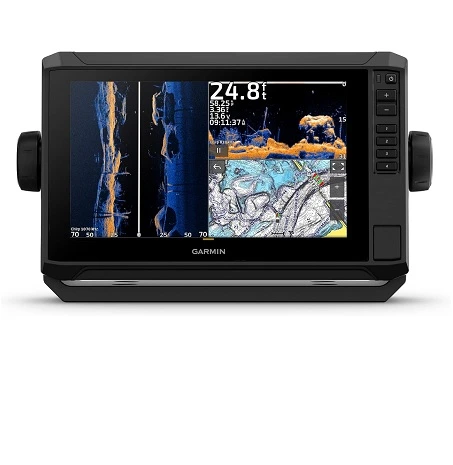
The Garmin Echomap UHD2 93sv is a 9″ Fish Finder/Chartplotter with a GT56UHD-TM Transducer and Garmin Navionics+® US Inland Mapping, high-resolution 1024 x 600 pixels display available on the market.
It is compatible with livescopes, offers wireless sharing with UHD2 units, and provides a full-boat network.
The Echomap UHD2 93sv comes preloaded with Garmin Navionics+ contour maps, which offer 44,000 lake maps, many with 1-foot contours.
You can upgrade to Garmin Navionics Vision+ in two ways: by downloading an update or using an SD card.
This upgrade adds more lakes with 1′ contours, relief shading, and other high-end mapping layers. The navigation system allows users to highlight depth zones using shallow water shading and depth range shading.
The device has 1 MicroSD slot and offers mapping options such as preloaded Navionics+ contours and Quickdraw live mapping.
At just a few hundred dollars more than the 73sv, it’s a worthwhile upgrade for smart anglers.
In this article, we will review Garmin ECHOMAP UHD2 93sv with GT56 Transducer, Specifications, Key Features, Pros, Cons, and FAQs
Garmin ECHOMAP UHD2 93SV Specifications
Specifications Garmin Echomap UHD2 93SV with GT56
Dimension 10.4″ x 6.5″ x 3.2″ (26.4 x 16.6 x 8.0 cm)
Weight 2.9 lbs (1.3 kg)
Waterproof IPX7
Touchscreen Yes
Display Type WSVGA, TN
Display Size 7.8″ x 4.5″, 9.0″ (19.8 x 11.5 cm, 22.9 cm)
Display Resolution 1024 x 600 pixels
Mounting Options Bail or flush
Input Touchscreen with Keyed Assist
Accepts Data Cards 1 microSD™ card; 32 GB maximum size
Waypoints 5,000
Track Points 50,000
Tracks 50 saved tracks
Navigation Routes 100
GPS Yes
Glonass Yes
Galileo Yes
Beidou Yes
Has Built-In Receiver Yes
Receiver 10 Hz
NMEA 2000 Compatible Yes
Supports WAAS Yes
Supports Multi-Band, Multi-Constellation GPS Yes
Built-In Auto Guidance+ yes (downloadable via ActiveCaptain app)
Garmin Navionics+ Inland & Coastal yes (see Additional)
Garmin Navionics+ (Coastal) yes (see Additional)
Garmin Navionics+ (Inland) yes (see Additional)
Tide Tables yes (see Additional)
Bluechart G3 Yes
Bluechart G3 Vision Yes
Lakevü G3 Yes
Lakevü G3 Ultra Yes
Garmin Navionics+™ Yes
Garmin Navionics Vision+™ Yes
Topo 100k Yes
Standard Mapping Yes
Garmin Quickdraw Contours Yes
AIS Yes
DSC Yes
Supports Fusion-Link™ Compatible Radios Yes
Activecaptain® Compatible Yes
Sailing Features Yes
Power Input 9 to 18 Vdc
Typical Current Draw AT 12 VDC 1.72 A
Maximum Current Draw AT 12 VDC 3.5 A
Maximum Power Usage AT 10 VDC 20.7W
Displays Sonar Yes
Power Output 500 W
Traditional Sonar (Dual Frequency/Beam) built-in (single channel CHIRP, 50/77/83/200 kHz, L, M, H CHIRP)
Clearvü built-in 260/455/800/1000/1200 kHz
Sidevü built-in 260/455/800/1000/1200 kHz
Panoptix™ Sonar Yes
Livescope Yes
NMEA 2000® Ports Yes
Garmin Marine Network Ports 1
12-Pin Transducer Ports 1
Bluetooth® Pairing Yes
Ant+ (Connectivity) Yes
Garmin Wi-Fi Network (Local Connection) Yes
Garmin ECHOMAP UHD2 93SV Features
Robust Design and High-Resolution Display
- Dimensions and Durability: Measuring 10.4″ x 6.5″ x 3.2″ and weighing 2.9 lbs, it’s both sturdy and portable.
- Water Resistance: An IPX7 rating ensures it can withstand splashes and brief submersion.
- Crystal-Clear Display: The 9-inch touchscreen boasts a 1024 x 600-pixel resolution, offering crisp and clear imagery.
Advanced Sonar Technology
- GT56 Transducer Excellence: Delivers high-definition scanning with traditional CHIRP, as well as ClearVü and SideVü technologies for a comprehensive view beneath and around the boat.
- Powerful Performance: With a 500 W output, it penetrates deep waters, enhancing fish detection capabilities.
Enhanced Navigation and Mapping
- Accurate GPS System: Integrates multiple satellite systems (GPS, Glonass, Galileo, Beidou) for precise location tracking.
Ample Storage for - Waypoints and Routes: Stores up to 5,000 waypoints and 50,000 track points, crucial for marking fishing hotspots.
User-Friendly Interface and Connectivity
- Easy-to-Navigate Interface: The touchscreen with keyed assist simplifies operation, making it accessible even for beginners.
- Expanded Connectivity: Features NMEA 2000® and Garmin Marine Network ports, Bluetooth®, ANT+, and Wi-Fi for seamless integration with various devices and networks.
Practical Mounting and Power Usage
- Flexible Mounting Options: Choose between bail or flush mounting for convenience.
- Efficient Power Consumption: Operates on 9 to 18 Vdc, with a typical current draw at 12 VDC of 1.72 A.
Extended Coverage with Garmin Navionics+
Garmin Navionics+ (Inland and Coastal):
The 95sv model, designed for users in Canada, Australia, and New Zealand, offers comprehensive mapping of both inland and coastal waters. This feature is invaluable for anglers who traverse diverse water bodies, providing detailed charts for a wide range of fishing environments.
Garmin Navionics+ (Coastal):
The 94sv U.S. coastal and 95sv UK/Ireland models cater specifically to coastal areas, offering detailed marine cartography. Ideal for sea anglers, these models provide critical navigation information for coastal waters, ensuring safety and enhanced fishing opportunities.
Garmin Navionics+ (Inland):
The 93sv U.S. lakes version is tailored for freshwater anglers, with an emphasis on U.S. inland water bodies. This specialized mapping aids in locating fish habitats in lakes, making it a perfect companion for inland fishing expeditions.
Tide Tables Integration
Models with Tide Tables: The inclusion of tide tables in the 93sv, 94sv, and 95sv models is a significant boon for anglers. Understanding tidal movements is crucial for coastal fishing, as it affects fish behavior. These models provide real-time tidal data, allowing anglers to plan their trips according to the most promising fishing times.
Pros:
- 9-inch high-definition touchscreen with 1024 x 600 resolution for clear visuals.
- Advanced sonar with traditional CHIRP, ClearVü, and SideVü for detailed underwater imaging.
- Integrated GPS, Glonass, Galileo, and Beidou systems for precise location tracking.
- Preloaded Garmin Navionics+ maps for comprehensive coverage of inland and coastal areas.
- IPX7 water-resistant build, durable for marine environments.
- Flexible mounting options with both bail and flush mount compatibility.
- NMEA 2000, Garmin Marine Network, Bluetooth, ANT+, and Wi-Fi connectivity.
- Efficient power usage with a typical current draw of 1.72 A at 12 VDC.
Cons:
- While the Garmin ECHOMAP UHD2 93sv offers advanced functionalities, it presents a steep learning curve for beginners and comes at a premium price point.
FAQs on Garmin Echomap UHD2 93sv Chartplotter
Conclusion
The Garmin ECHOMAP UHD2 93sv is the best fish finder with a 9-inch high-definition display, sonar capabilities, GPS accuracy, and detailed Garmin Navionics+ maps. It features CHIRP, ClearVü, and SideVü, multiple satellite systems, and is water-resistant (IPX7) for marine use. The device offers versatile mounting options, NMEA 2000 and Wi-Fi connectivity, and efficient power consumption.

Gary Burrell
Born in 1989, Gary Burrell is an Electrical Engineering graduate from the University of Tennessee. With 20+ years of experience, he has transitioned from engineering roles to becoming the Chief Content Editor. Gary’s unique blend of technical knowledge and editorial expertise has made him an essential figure in content creation, ensuring clarity and accuracy. His journey from an engineer to an editor showcases his adaptability and commitment to continuous learning.