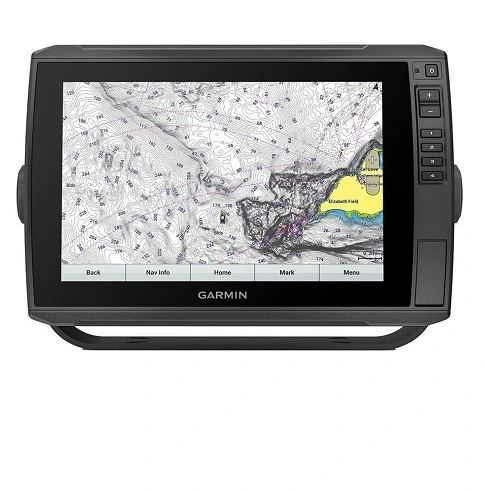
Garmin ECHOMAP Ultra 126sv with Panoptix LiveScope
Home | Brand: Garmin | Series: Echomap Series | Model: 126SV | Our Score: 4.9/5
The Garmin ECHOMAP Ultra 126sv is a revolutionary chartplotter that offers superior fishing and navigation capabilities. It features innovative sonar capabilities, including forward-facing sonar at the bow and cutting-edge side-imaging technology at the console, which are particularly beneficial for bass anglers navigating shallow waters.
The LiveScope Scanning System, integrated with a 12″ touch-screen combo, BlueChart G3 coastal maps, LakeVü G3 inland maps, and Navionics data, provides real-time underwater views, enhancing fishing strategies. The chartplotter’s user-friendly design allows seamless data sharing with other devices, making it a top choice for efficient marine navigation.
The evolution of fish finders, from basic sonar to the Garmin LiveScope, has transformed the way we approach bass fishing. The Garmin ECHOMAP Ultra 126sv is a must-have for every angler seeking precision and efficiency on the water.
Garmin ECHOMAP Ultra 126sv Specifications
Specifications Garmin Echomap Ultra 126sv
Dimension 13.4″ x 9.0″ x 3.9″ (34.1 x 22.9 x 9.8 cm)
Touchscreen Yes
Input Touchscreen with Keyed Assist
Display Size 10.3″ x 6.4″; 12.1″ diagonal (26.1 x 16.3 cm; 30.7 cm diagonal)
Display Resolution 1280 x 800 pixels
Display Type WXGA, IPS
Weight 5.5 lbs (2.5 kg)
Waterproof IPX7
Mounting Options Bail or flush
Accepts Data Cards 2 microSD cards
Waypoints 5000
Track Points 50,000
Tracks 50 saved tracks
Navigation Routes 100
Has Built-In Receiver Yes
Receiver 10 Hz
NMEA 2000 COMPATIBLE Yes
NMEA 0183 COMPATIBLE Yes
GPS Yes
Supports WAAS Yes
Bluechart (Coastal) Yes
LAKEVU (Inland) Yes
Tide Tables Yes
LAKEVÜ G3 Yes
LAKEVÜ G3 Ultra Yes
Garmin Navionics+™ Yes
Garmin Navionics Vision+™ Yes
Topo Yes
Standard Mapping Yes
Garmin Quickdraw Contours Yes
AIS Yes
DSC Yes
Supports Fusion-Link™ Compatible Radios Yes
Activecaptain® Compatible Yes
Sailing Features Yes
Displays Sonar Yes
Power Output 600 W
Traditional Sonar (Dual Frequency/Beam) built-in (single channel CHIRP, 70/83/200 kHz, L, M, H CHIRP)
Clearvü built-in 260/455/800/1000/1200 kHz
Sidevü built-in 260/455/800/1000/1200 kHz
Panoptix™ Sonar Yes
Livescope Yes
NMEA 2000 PORTS 1
Connections NMEA0183 Input Ports 1
NMEA 0183 INPUT (TX) PORTS 1
Garmin Marine Network Ports 2 (large connector)
12-Pin Transducer Ports 1 LVS sonar; 1 scanning sonar
Power Input 9 to 18 Vdc
Typical Current Draw at 12 VDC 3.0 A
Maximum Current Draw at 12 VDC 3.3 A
Maximum Power Usage at 10 VDC 26.2W
Garmin ECHOMAP Ultra 126sv Key Features
As someone who’s spent years around boats and marine tech, I’ve got to say, this new fish finder/chartplotter combo really caught my eye. It’s not just another gadget – it’s a game-changer for anyone who loves being on the water, whether you’re fishing, sailing, or just cruising around.
Compact Design Meets High-Tech Display
The first thing that strikes you about this fish finder/chartplotter is its compact, sleek design. Measuring 13.4″ x 9.0″ x 3.9″, it fits neatly on a variety of boat consoles. But don’t let its size fool you. The device boasts a 12.1″ diagonal touchscreen with a 1280 x 800 WXGA resolution, offering crystal clear visuals on an IPS panel. It’s impressively lightweight at 5.5 lbs, and with its IPX7 waterproof rating, it’s clearly built to withstand the elements. Whether you choose to bail or flush mount it, installation is a breeze.
Navigational Mastery with Enhanced Memory
Navigational efficiency is paramount in this device. It effortlessly handles extensive mapping data with its dual microSD card slots.
You can store an impressive 5000 waypoints, track 50,000 points, and manage 50 saved tracks. Planning and following complex navigation routes, up to 100, is smoother than ever, making it an invaluable tool for seasoned sailors and casual boaters alike.
Precision Tracking with Advanced Sensors
Under the hood, this unit is equipped with a 10 Hz built-in receiver, guaranteeing swift and accurate position tracking. It integrates seamlessly with NMEA 2000 and NMEA 0183 systems, broadening its utility across various marine setups. The inclusion of GPS with WAAS support adds another layer of precision, ensuring reliable navigation in all conditions.
Extensive Map Coverage and Support
Preloaded with Bluechart and LAKEVU maps, the device caters to both coastal and inland water navigation. Its versatility is further enhanced by supporting a wide range of additional maps, including LAKEVÜ G3, Garmin Navionics+, and more. This feature makes it a comprehensive companion for any maritime adventure.
Cutting-Edge Chartplotter Features
Safety and communication are at the forefront with its AIS and DSC capabilities, ensuring you’re always in control and connected. The device’s compatibility with Fusion-Link radios and the ActiveCaptain app provides additional connectivity, making it a modern sailor’s dream. The specialized sailing features are a boon, tailor-made for the sailing enthusiast.
Unmatched Sonar Capabilities
The sonar performance is where this device truly shines. With traditional sonar, Clearvü, and Sidevü options powered by a 600 W output, the clarity and detail in underwater imaging are unmatched. The addition of Panoptix and Livescope sonars offers real-time, detailed views, making it an essential tool for anglers.
Diverse Connectivity for Enhanced Integration
The device is well-endowed with connectivity options, including NMEA 2000 and NMEA0183 ports, Garmin Marine Network ports, and specialized 12-pin transducer ports. This extensive connectivity ensures it can easily become the nerve center of your boat’s navigation system.
Efficient and Reliable Power Use
Efficient power management is key in marine electronics, and this device doesn’t disappoint. Operating within a 9 to 18 Vdc range and with a typical current draw of 3.0 A at 12 VDC, it’s designed for extended use without draining your boat’s battery. The peak current draw at 3.3 A and the maximum power usage at 10 VDC of 26.2W attest to its efficient energy use.
What’s in the box?
- ECHOMAP Ultra 126sv with BlueChart g3 and LakeVü g3 for U.S.
- GT56UHD-TM transducer
- Power/data cable
- Tilt mount with quick release cradle
- Garmin Echomap Ultra 126sv Flush Mount
- Garmin Echomap Ultra 126sv Screen Protector
- Hardware
- Documentation
Pros:
- LiveScope Technology: Offers real-time, unparalleled sonar image clarity.
- Intuitive Interface: Easy to navigate, user-friendly for all experience levels.
- High-Definition Display: 12.1″ touchscreen with crisp 1280 x 800 WXGA resolution.
- Customizable Mapping: Preloaded with detailed Bluechart and LAKEVU maps, with depth range color customization.
- Durable Design: Robust build with IPX7 waterproof rating, suitable for various marine environments.
- Flexible Mounting: Multiple options including bail and flush mounting.
- Seamless Device Integration: Compatible with various transducers and Garmin devices, including the Garmin Force trolling motor.
- Extensive Waypoint and Route Storage: Capacity to store up to 5000 waypoints and 100 navigation routes.
Cons:
- Side Imaging Performance: The side imaging may not be as effective as competitors, particularly for soft targets.
- Learning Curve: Switching from other brands to Garmin’s interface and features might require a period of adjustment.
- Built-in Mapping Limitations: The preloaded maps may not fully meet the needs of users accustomed to different mapping systems.
- Price: The advanced features come at a higher cost, which could be a significant factor for some buyers.
FAQ: Garmin Echomap Ultra 126sv
Conclusion
The Garmin ECHOMAP Ultra 126sv with Panoptix LiveScope is a groundbreaking fish finder with real-time, crystal-clear images, offering unparalleled clarity and detail in locating fish and understanding underwater structures. Its 12” display and user-friendly interface cater to both seasoned mariners and newcomers.
However, its side imaging may not match competitors, especially on softer underwater targets. Transitioning to Garmin’s interface may require adjustment, especially for users loyal to different map systems. Despite its higher investment, LiveScope technology makes it a standout choice in the fishfinder market.

Gary Burrell
Born in 1989, Gary Burrell is an Electrical Engineering graduate from the University of Tennessee. With 20+ years of experience, he has transitioned from engineering roles to becoming the Chief Content Editor. Gary’s unique blend of technical knowledge and editorial expertise has made him an essential figure in content creation, ensuring clarity and accuracy. His journey from an engineer to an editor showcases his adaptability and commitment to continuous learning.