GPSMAP® 8422 MFD | Marine Chartplotter Review
Brand: Garmin | Model: 010-01511-00 | Our Score: 5/5
The GPSMAP® 8422 MFD is a top-tier marine chartplotter for anglers and sailors, offering advanced navigation and sonar capabilities.
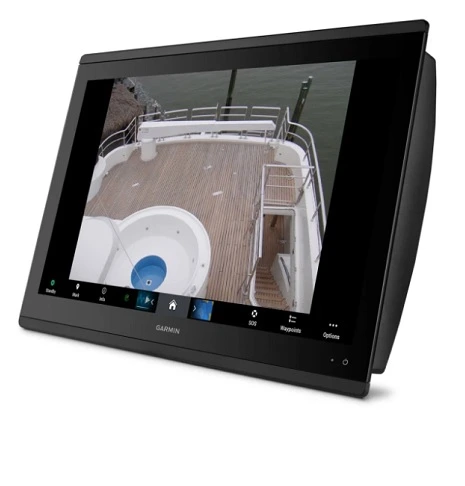
The Helm Premium 22-inch full HD marine display with pinch-to-zoom touchscreen control offers high resolution, 1-touch settings for docking, cruising, fishing, and anchoring. It features a high-performance processor for faster map drawing and video processing. It also has a sunlight-readable IPS touchscreen, Garmin Navionics+™ for coastal and inland mapping, and Wi-Fi® and ANT® technology networking options.
It supports traditional CHIRP and scanning sonars (ClearVü and SideVü) for detailed underwater imaging. Installation is simplified with mounting options and the optional GRID™ 20 remote control.
The review discusses the specifications, key features, and FAQs of the GPSMAP 8422 Multifunction Display (MFD) Unit.
GPSMAP® 8422 MFD Specifications
Specifications Garmin GPSMAP 8422 MFD
Dimension 20.8″ x 13.8″ x 2.8″ (52.8 cm x 35.1 cm x 7.1 cm)
Weight 15.63 lbs (7.09 kg)
Waterproof IPX7
Touchscreen Yes
Display Type FHD, IPS
Display Size 18.8″ x 10.6″; 21.5″ diagonal, 47.8 cm x 27.0 cm; 54.6 cm diagonal
Display Resolution 1920 x 1080 pixels
Mounting Options Flush or flat
Accepts Data Cards 2 SD Cards (with Garmin SD card reader accesory)
Waypoints 5000
Track Points 50,000
Tracks 50 saved tracks
Navigation Routes 100
NMEA 2000 Compatible Yes
NMEA 0183 Compatible Yes
Tide Tables Yes
Bluechart G3 Yes
Bluechart G3 Vision Yes
LAKEVÜ G3 Yes
LAKEVÜ G3 Ultra Yes
GARMIN NAVIONICS+™ Yes
GARMIN NAVIONICS VISION+™ Yes
Topo 100K Yes
Standard Mapping Yes
Garmin Quickdraw Contours Yes
Raster Chart Support Yes
Smart Mode Compatible Yes
AIS Yes
DSC Yes
Supports Fusion-Link™ Compatible Radios Yes
GSD Black Box Sonar Support Yes
GCV Black Box Sonar Support Yes
Activecaptain® Compatible Yes
Grid (Garmin Remote Input Device) Compatible Yes
Wireless Remote Compatible Yes
Sailing Features Yes
Spoken Audio Alerts Yes
Onehelm Support Yes
Power Input 10-35 Vdc
Typical Current Draw At 12 VDC 3.9 A
Maximum Current Draw At 12 VDC 4.9 A
Maximum Power Usage At 10 VDC 59W
Displays Sonar Yes
Traditional Sonar (Dual Frequency/Beam) Yes (with external black box, sold separately)
Clearvü yes (with GCV™ black box, sold separately)
Sidevü yes (with GCV™ black box, sold separately)
Panoptix™ Sonar Yes
Livescope Yes
NMEA 2000® Ports 1
Connections NMEA0183 Input Ports 4
NMEA 0183 Input (TX) Ports 2
Video Input Ports 1 (BNC composite); 1 HDMI (HDCP compliant)
Video Output Ports 1 HDMI
J1939 Ports 1
Garmin Marine Network Ports 4
Usb Ports Yes
Bluetooth® Pairing Yes
ANT+ (Connectivity) Yes
Garmin Wi-Fi Network (Local Connection) Yes
GPSMAP® 8422 MFD Key Features
General Design and Display
This fish finder/chartplotter is designed with practicality and efficiency in mind. It has a compact size of 20.8″ x 13.8″ x 2.8″, and it weighs 15.63 lbs, making it a solid yet manageable addition to any vessel. It is also waterproof with an IPX7 rating, ensuring it can handle wet marine conditions. The device features a convenient touchscreen, making it easy to navigate. The screen is large and clear, with a size of 18.8″ x 10.6″ and a Full HD resolution of 1920 x 1080 pixels, providing excellent visibility. You can mount it either flush or flat, depending on your boat’s setup.
Maps and Memory
When it comes to storing maps and navigation data, this device is quite capable.
It has slots for two SD cards, allowing for plenty of extra storage.
It can save up to 5000 waypoints, 50,000 track points, and 50 tracks.
Additionally, it can manage up to 100 navigation routes, making it great for planning trips in various water bodies.
Sensor Compatibility
This unit works well with other marine equipment, as it’s compatible with both NMEA 2000 and NMEA 0183 systems.
This means it can easily share data with other devices on your boat, helping you navigate and find fish more effectively.
Mapping Options
The device is equipped with built-in tide tables, which are essential for coastal navigation. It also supports various Garmin maps, including Bluechart G3 and LAKEVÜ G3, which are helpful for detailed and accurate marine charting. Additionally, it can use Garmin Quickdraw Contours for personalized mapping.
Chartplotter Features
In terms of chartplotting, the device has several advanced features. It’s compatible with Smart Mode, which makes it easier to use. It supports marine networks like AIS and DSC, and can connect with Fusion-Link™ compatible radios. For sonar, it works with both GSD and GCV Black Box Sonar. The unit is also compatible with Activecaptain® and supports wireless remote control. It even offers sailing features and spoken audio alerts, adding to its versatility.
Power Usage
The fish finder/chartplotter is energy-efficient, operating within a 10-35 Vdc range.
It typically draws 3.9 A at 12 VDC and can go up to 4.9 A.
Its maximum power usage is 59W at 10 VDC, making it a good choice for long outings.
Sonar Technology
The device is equipped to display various types of sonar readings. It supports Traditional, Clearvü, and Sidevü sonar, as well as Panoptix™ and Livescope, though some of these require additional equipment.
This makes it a versatile tool for different fishing conditions.
Connectivity
This unit offers a range of connectivity options. It has one NMEA 2000® port, multiple NMEA0183 and J1939 ports, and four Garmin Marine Network ports. For video, it has BNC composite and HDMI ports. It also includes USB ports, supports Bluetooth® pairing, ANT+ connectivity, and can connect to a local Garmin Wi-Fi network.
What’s In The Box?
- GPSMAP 8422 MFD Chartplotter
- Trim piece snap covers
- GPS 24xd NMEA 2000 (with pole mount, flush mount and under deck mount adapters)
- Protective cover
- Flush mount hardware
- Power cable
- NMEA 2000 2 m backbone/drop cable
- NMEA 2000 6 m backbone cable
- NMEA 2000 power cable
- NMEA 2000 T-connector & terminator kit
- Documentation
Pros:
- Robust Waterproof Design: IPX7 rating ensures durability in marine environments.
- High-Resolution Touchscreen: Full HD, IPS display provides clear and detailed visuals.
- Extensive Memory Capacity: Accommodates up to 5000 waypoints and 50,000 track points.
- Versatile Mapping Support: Compatible with a range of Garmin charts and features integrated tide tables.
- Advanced Chartplotter Features: Supports Smart Mode, AIS, DSC, and various sonar types for enhanced navigation.
- Efficient Power Management: Operates within a 10-35 Vdc range, ensuring power efficiency.
- Comprehensive Connectivity Options: Includes multiple ports and supports Bluetooth®, ANT+, and Wi-Fi connections.
Cons:
- High Cost: Expensive due to advanced features.
- Complex Interface: Can be challenging for beginners.
- Limited Non-Garmin Compatibility: Best suited for use with Garmin-specific accessories.
FAQs for GPSMAP® 8422 MFD | Marine Chartplotter Review
Related: Garmin GPSMAP 1042xsv Review
Conclusion
The GPSMAP® 8422 MFD is a high-end marine chartplotter that offers advanced technology, user-centric design, and versatile functionality. It features a 22-inch full HD touchscreen with the highest resolution in the marine market, making it ideal for various lighting conditions.
The device is highly regarded for its ease of navigation and control, with one-touch setting access for different modes and a high-performance processor for fast map drawing. It excels in integration, connecting with various sonar technologies, autopilot, apps, engine data, and multimedia. The chartplotter’s network compatibility is extensive, supporting radar, multiple screens, sensors, and more.
It offers robust connectivity options, including Wi-Fi®, Ethernet, and HDMI. SailAssist features add value for sailing activities, and the device is easy to update.
Overall, the GPSMAP® 8422 MFD is a top-tier choice for marine navigation, suitable for both recreational and professional applications.